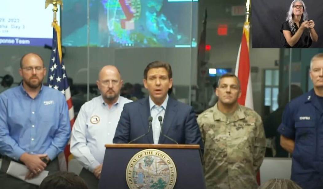
Florida Republican Gov. Ron DeSantis warned Floridians in the path of Hurricane Idalia to consider evacuating, especially anyone vulnerable to storm surge.
“The National Hurricane Center advisory includes that if this storm hits at high tide, the storm surge could reach eight to 12 feet in some areas, and so that would be a life-threatening storm surge,” DeSantis said at a Tuesday morning press briefing held at the State Emergency Operations Center, Tallahassee.
“You run from the water, and you hide from the wind; if you're there in that storm surge, you're putting your life in jeopardy when it gets to be that high,” he said.
“You will start certainly seeing effects of this in different parts of the state later on today,” he said. “You still have time this morning to be able to make your final preparations.”
DeSantis said he has prepared personnel and equipment for the storm, including mobilizing 5,500 National Guardsmen.
“We have eight urban search and rescue teams activated and over 580 search and rescue personnel ready,” he said. “We have delivered 431 pallets of water, 303 pallets of MREs, and over 1,200 tarps to communities that may be impacted.” MREs are military-ready-to-eat meals.
The governor said the state stood up more than 20 shelters, and there are an additional 20 special needs shelters in the process of opening all over the state.
The governor put a hold on his presidential campaigning, canceling two stops in South Carolina and sending Sunshine State First Lady Casey DeSantis as his surrogate.
During the 2022 campaign, DeSantis suspended his campaign to lead the state’s response and recovery to September’s hurricanes Ian and Nicole.
It was a move that proved you do well when you do good.
The governor said he was staying in the state as the storm plays out, as he did 11 months ago.
“This is no different. I mean, you remember Ian, we were in the midst of a governor campaign. I had all kinds of stuff scheduled, not just in Florida, but around the country,” he said.
“We were doing different things, and you do what you need to do, and so that's what we're doing, so it's going to be no different than what we did during Hurricane Ian,” he said.
The National Weather Service declared the storm a hurricane at 5 a.m. Tuesday as it passed Cuba and made its way toward Florida’s Big Bend, the northeast corner of the Gulf of Mexico. This area includes Tallahassee, the state capital, and the campuses of Florida State University and Florida Agriculture and Mechanical University.
The hurricane hits northwest Florida five years after Hurricane Michael devastated the Florida Panhandle in 2018, making landfall roughly 100 miles west of the so-called Big Bend, the notch on the state’s coast that forms Apalachee Bay.
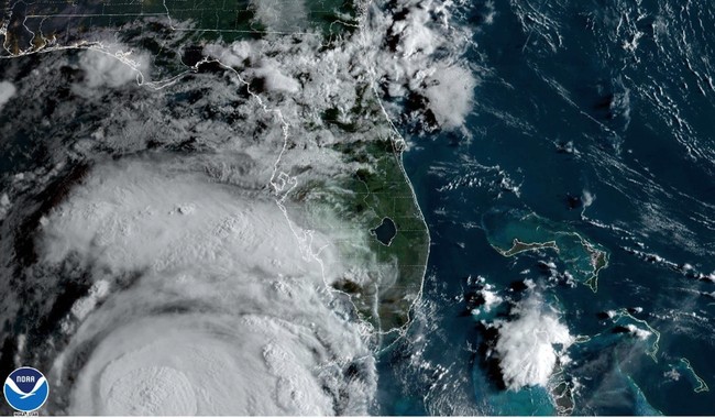
“This is going to be a major hurricane, likely a Category 3, and where it's scheduled to hit along this Big Bend, and we've not really had a hurricane strike this area for a long, long time,” DeSantis said.
“I think you got to go back to the 1800s before you would see a path like this, and so those coastal areas there have not necessarily been through this before,” he said.
“Obviously, there's still going to be impact in Tampa Bay, but every notch west, it's a little less impact to Tampa,” DeSantis said.
The governor cited different models, including by the National Hurricane Center, but he did not voice full confidence in their ability to call the storm’s track.
“Some of the models had to go even further west into Tallahassee,” he said. “NHC has not been willing to go that far, and some of these models have been very bad, to be honest with you, if you look at past storms,” he said.
“There's some models that say it may go even further west, so places like Tallahassee where we are today, certainly you could end up having it hit Tallahassee directly.”


Join the conversation as a VIP Member